
A PDF version is available here.
At the end of January, I travelled up to Scotland to get the low down on lime mortars from David Wiggins of Clach Conservation, and to visit friends in the Dundee area. The course was on 24 Jan – the approach of Storm Éowyn hadn’t sunk in, and I got a call when I was somewhere near Carlisle to say that as the Scottish transport network was shut down for the day, the course was postponed. It was too late to turn back, so I picked up my hire car in Dunfermline and drove straight up to Dundee before the weather arrived.
(Before I get to the point: the rescheduled course is on 14 March and is still open for registration. David combines a deep knowledge of lime mortars and masonry structures and it’s sure to be a valuable day.)
On my trip I stopped in Tealing and Abernyte, and both offered up some interesting subjects. Let’s look first at the Baledgarno Den near Abernyte. A “den” is a narrow, probably wooded, valley, and this could be the type specimen.
The NLS viewer is a fantastic resource. We can see in the 1860s OS map water power was heavily utilised in this valley, with sluices, dams, leats and mills evident. On the ground today, the intensity of the exploitation of the burn is even clearer, though the remains are in a state of decay, helped along by the trees that grow so enthusiastically in this part of Scotland.
The first structure we came to was also one of the harder to explain.

This surely isn’t a bridge: it is too narrow, needlessly long span, and there is a proper bridge just upriver. For water control? Perhaps, though in what way wasn’t clear.

A glimpse upriver at this stage revealed something of interest, but from here we first turned downstream. (I worked out eventually, but not yet, that I would need to switch to manual focus to get anything but the twigs sharp.)
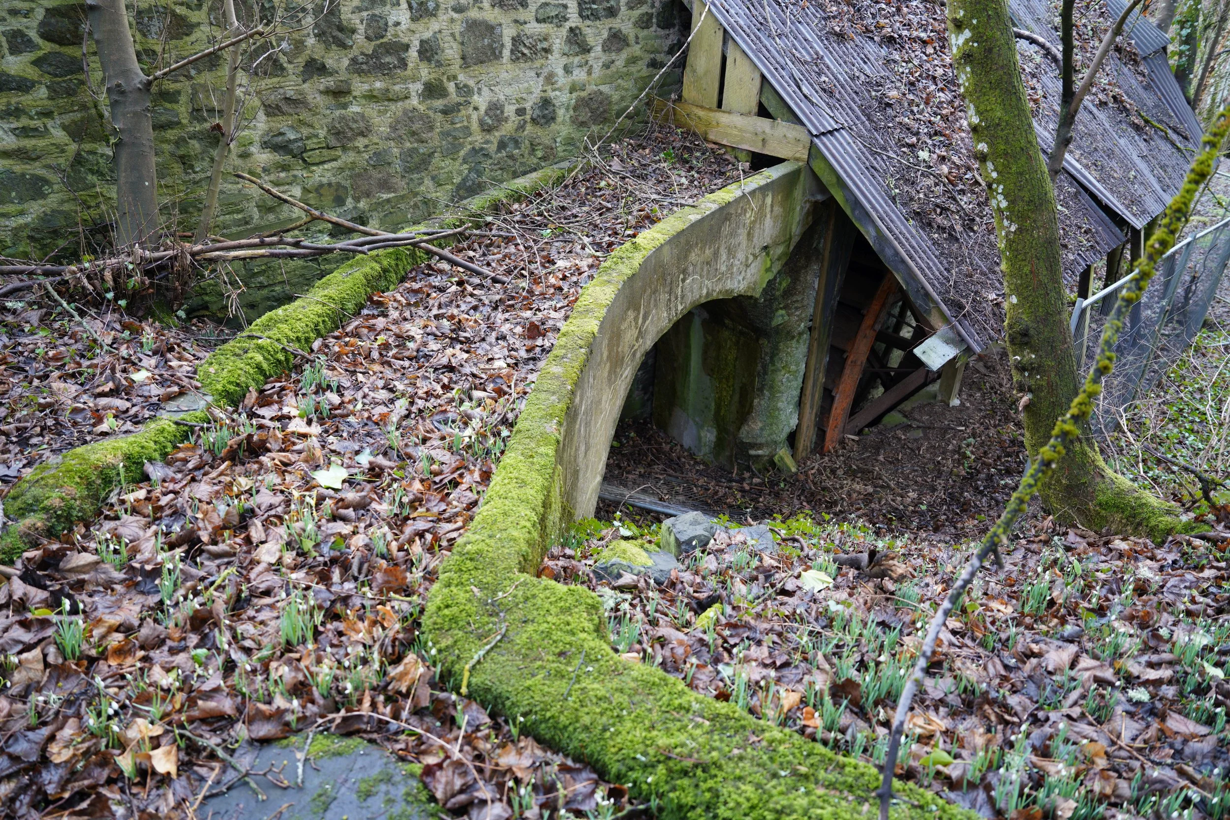
Next, we came to the unusual feature below, difficult to interpret from photographs alone.

The burn enters from the top left, where it splits and runs both toward us and along the top of the photograph. The ground within the horseshoe of streams drops down sharply enough that there must surely have been something like a waterfall here originally.
The two streams then make the drop in level and immediately recombine (below).

The near branch flows down what seems now to be simply a waterfall (below left), while the far branch comes via the broken up remains of a concrete spillway (below right). Between the two, the ground is retained by a dry stone retaining wall (visible in the middle, below left).


In the distance downriver the next bridge is visible (right), with some presumably slightly more modern infrastructure.
So far, so confusing!


Retracing our steps, we get back to the bridge glimpsed as we turned downstream (above left). It turns out, like so much else, to be of concrete. Semi-circular, the low abutments are no more than walls for the arch to sit on (right). I suppose there is some rubble behind the arch as backing; whether the stones we see are part of that or the remains of a wing wall is unclear.
Perhaps the arch is reinforced, but the quality of the concrete and the lack of rust staining suggest not.

Does a different angle on the narrow “bridge” from before shed any light? Its abutments are slightly wider than the arch, but not much. It is possible there was some concrete below in the river, since undermined and carried downstream in floods. A close look at the far abutment reveals a nib beneath the arch that could have retained stop logs. Perhaps this was simply to divert flow into a channel to the right. If so, there is little evidence of that channel now.

The prevalence of concrete raises questions about the dates for all this. Then a quick look at some unusual ruins across the river gives us a hint: there was concrete in use here by 1892. The wall just visible through the trees to the right may be a dam. I didn’t get behind our dated wall, and I’m not sure of its role.

Next up, some mysterious columns. I thought these were concrete again, but in the photo the far one appears to be stone with render. To carry a mill leat, I suppose.
After that, there is a silted up dam and spillway and various water control structures that I feel must be much later than 1892, then some rather wonderful decaying mill buildings.

Across the river in timber, presumably a workshop or store, and the mill itself in a mixture of stone and timber. Leaded windows, damaged but not completely gone, must long predate the plastic gutter. Sadly the rot is well developed.


Round the corner, an aqueduct (gratuitously curved?).
And do we have a water wheel still…

Yes we do! Though not for much longer.

There was a glimpse of a wee bridge crossing the river to the workshop. We’d better take a look.
The right wingwall has gone, and the bank behind is being taken by the flood flow eddies.
The concrete spandrel wall provides an edge to a narrow strip of, apparently, a dry brick arch over dry stone walls.
I’m not sure what to say about what’s happening beyond that!

This doesn’t look like the remains of an arch, the brick rubble is in straight segments. Just rubble dumped on the corrugated steel? Again, I’m intrigued about dates.
But not as much as I am about what loads this has carried.
There was one more interesting bridge on this walk that can wait for another time.